
FIELD NOTES BLOG
Summer Storms: Meteorology and our Local Environment
Summer days have an intense energy. For us, it’s easy to pack a lot of activity into long, sunlight-filled days. The atmosphere is packed in a different way, with thick, heavy humidity and sun-baked heat. You have probably experienced one of these particularly sweltering days where periods of calm are interrupted with a sudden summer storm. One moment you are relaxing, the next, you hear the rumbling of thunder, and it begins to rain, instantly cooling the hot ground and taking the stickiness from the air. You don’t have long to take in the scene as the intensity of the heat gives way to an intense storm. This is a different kind of energy in the air; this is a summer storm.
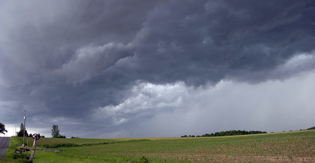
But what makes summer the season of storms? And what landscape factors make Illinois the perfect staging ground for storms? Keep reading to find the answers to these questions and hear from our State Climatologist, Dr. Trent Ford!
The Makings of a Storm
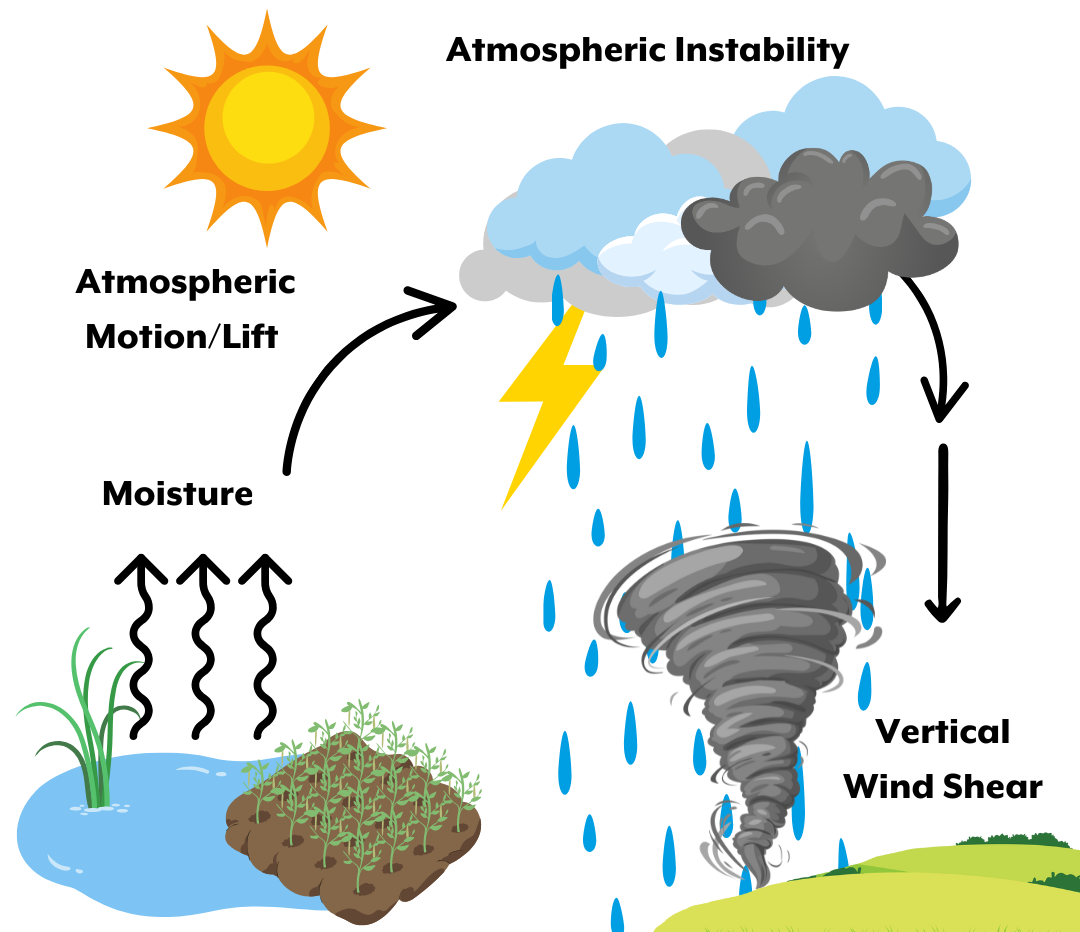
Storms need three things to develop: moisture, atmospheric instability, and atmospheric motion. Adding a vertical wind shear to the mix can lead to a severe storm, like a tornado. Warmer summer months offer the perfect conditions for this development to occur.
1. Moisture
Moisture accumulates in the air as warm water evaporates from oceans, lakes, streams, and other water reservoirs due to rising seasonal temperatures. This water is held in warm air that can hold more moisture than cool air. Humidity is a measure of water vapor content in the air. All of the evaporated moisture makes the air feel more humid or sticky because our sweat evaporates from our skin much more slowly in humid air than in dry air. The moisture in the air makes it possible for storms to produce clouds and rain when combined with other factors.
2. Atmospheric Instability
After the moisture evaporates and is held in the air, it needs to rise and condense to form storm clouds. This need for rising air is possible due to drastic differences in temperature between the air layers, creating atmospheric instability. On hot days, the air near the Earth’s surface heats up, creating warm, less dense air that wants to rise above the cool, more dense air. The larger the temperature difference between the warm air layer closer to the Earth’s surface and the cool air layer above, the more unstable the air.
3. Atmospheric Lift
Lastly, a storm needs a source of lift to equalize the atmospheric instability.
Unequal Heating: can be initiated by the sun heating the Earth’s surface at uneven rates. A vegetated area will heat up more slowly than a paved surface, and this unequal heating causes different air densities that start to lift and create atmospheric currents.
Colliding Air Fronts and Dry Lines: When a cold front and warm front collide, the colder, denser air will sink, and the warmer, less dense air is forced to rise rapidly, which can lead to thunderstorm formation. Similarly, in dry lines, differences in moisture content can pull the dense, dry air under the less dense, moist air.
Geologic factors: Air is pushed upward when it encounters a mountain and may form storm clouds. This is known as orographic lift.
Outflow Boundaries: can be caused by storms themselves! The newly rain cooled air under the storm acts as a cold front as it tries to push out ahead of the storm and consequently nudges warm air upwards. This can lead to new thunderstorm development.
These ‘nudges’ and the resulting air movement due to density inequalities cause pressure differences that further drive the formation of storms. Air tends to move from high to low pressure in an attempt to equalize. When warm, less dense air rises, it leaves a pocket of low atmospheric pressure near the Earth’s surface. The newly created pressure gradient causes surrounding air to quickly fill the low-pressure zone. That air may then warm and rise, repeating the chain of events that leads to further storm formation.
4. Wind
The storm has now formed, but how powerful will it be? The result depends on a final factor: wind. More drastic wind updrafts and downdrafts will give the storm the ability to better maintain its inflow of warm, moist air to fuel its continuation. Speaking of wind directions, vertical wind shear is the change in wind speed and direction as altitude, or vertical height, increases. Wind shear can bring horizontal rotation to the atmosphere, known as a mesocyclone, that can contribute to the creation of supercells. A supercell is a strong storm with a rotating updraft that can produce large hail, powerful winds, flash flooding conditions, and tornadoes. You can recognize a supercell by its tall, anvil-shaped cloud that will reach high into the sky and extend far to the east. However, just as wind can strengthen a storm, it can also weaken it by separating the warm air source from the core of the storm
Illinois: Setting the Stage for Storms
Beyond these storm ingredients, our local environment in Illinois also influences the conditions needed to create a summer storm.
According to Illinois State Climatologist, Dr. Trent Ford, “the biggest local influence on summer storm formation in northern Illinois is moisture contribution from the land. Water evaporation from the soil and transpiration from plants (including crops) contributes significantly to the amount of moisture in the atmosphere. … Some research has suggested the expansion of corn production in the central US has also had an impact on storm formation and intensity in the Midwest during the summer.”
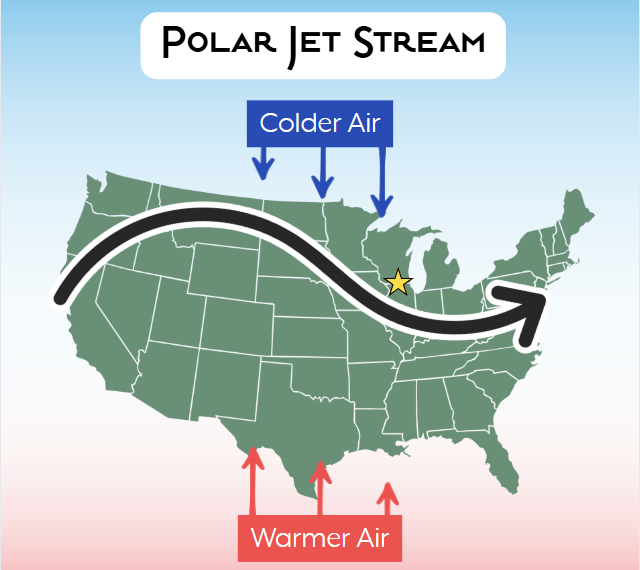
Illinois’ location in the Midwest makes it subject to extremes of temperature and precipitation. Illinois receives 3 to 4 times more solar energy in the summer than it does in the winter, meaning summer and winter temperatures are pushed to extremes. Illinois is situated where cold polar air from the north and hot, humid air that came from the Gulf in the South interact. Furthermore, Illinois sometimes finds itself on the path of the polar jet stream, a fast, high-altitude wind current that flows from west to east, forming a boundary between these air masses. The differing air mass interactions fuel low-pressure storms with the moisture, instability, and motion that they need to form.
Northern Illinois has flat plains, urban climates, and Lake Michigan as additional local contributors. The relative flatness of Northern Illinois means there are fewer natural wind breaks on the land, which can make it easier for high winds to persist and tornadoes to take hold. Northern Illinois is home to cities including Chicago, and even closer to home, Rockford. However, the numerous buildings and paved surfaces that comprise our cities have a greater potential to absorb heat, which makes those areas warmer and more likely to produce precipitation. Although Illinois is inland, its proximity to Lake Michigan influences wind direction and speed while bringing moderated temperatures to Chicago. Water temperatures stay more constant than land, so air going over the lake results in warmer winter temperatures and cooler summer temperatures. This can also produce less summer precipitation and more winter precipitation. This phenomenon is known as the lake effect.
Looking to a Future with Severe Weather
Illinois Severe Weather Trends
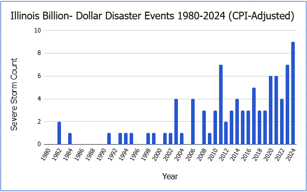
Illinois experiences a notable amount of severe weather in the summer months. Thunderstorms make up half of the annual precipitation. There is an average of 60 storms per year, half of which fall in the warm summer months. State climatologist Ford said, “Summer storms are producing more intense rainfall, which increases the risk of excessive water problems like localized flooding, soil erosion, etc. Scott Lincoln at the Chicago National Weather Service Office led a recent study on extreme rainfall events in Chicagoland, that shows an increase in the frequency and intensity of these events.” According to NOAA, there have been 92 severe storm events in Illinois with losses exceeding $1 billion from 1980-2024. In this 44-year span, 53% of the 92 storms have occurred in the last 10 years. Following this trend, the frequency and intensity of severe storms are expected to continue to increase as conditions become more favorable for storm formation. The average temperature is rising, leading to more evaporation of moisture, greater atmospheric instability, and stronger lifting mechanisms. The rising temperature stems from the transfer of energy from the ground to the sky as we burn fossil fuels, releasing greenhouse gases that insulate our atmosphere beyond pre-industrial conditions. This process has and will continue to impact the severity of each passing summer storm season.
Summer Storm Takeaway
According to State Climatologist Ford, “One of the most important takeaways about summer storms, to me, is that the precise location of the most severe storm conditions (e.g., strongest winds, hail, heaviest rain) is very difficult to accurately predict even just hours ahead of the storm. NWS scientists do a great job forecasting and communicating summer storm risk across a region, like Chicagoland or the Rockford area, but our current state-of-the-art techniques and models cannot give the exact location of where the heaviest rain will fall or where the strongest winds will blow at very fine spatial scales, like specific neighborhoods. This means that folks need to prepare for the significant impacts storms can bring anytime the NWS is predicting a risk of storms in a region.”
Preparing Yourself for a Storm
Additionally, when I asked State Climatologist Ford about what individuals can do to better prepare for the summer storm season, he told me about how people can keep themselves safe. “As we get into the summer, it's important for folks to have some important things on hand in case of storm impacts. Fresh water, batteries and a working flashlight, non-perishable food are must haves. When severe weather and storms are expected, make sure folks know what they need to do in case of severe weather, and where family and friends are in case they need assistance. Making sure your phone is charged is also very important leading up to a severe weather event.”
Contributing to Storm Community Science
You can also contribute to a community science program during these storm events by joining the Community Collaborative Rain, Hail & Snow Network (CoCoRaHs) at https://cocorahs.org/. “... folks can measure precipitation and help fill in the gaps between precipitation events. It's really important in the summertime when we can get big differences in rainfall from just a single storm across a small area.” Contributing to local science can help you gain a better understanding of storms while also helping scientists!
Next time you see the sun on a hot day, give way to dark clouds rolling in; you will not only know that a storm is about to begin, but also the mechanisms that feed our powerful summer storms.
Sources
NOAA - Ingredients for a Thunderstorm
National Weather Service - Air Pressure
National Weather Service - Severe Weather Topics: What is Wind Shear?
National Weather Service - What is a Supercell?
State Climatologist Office for Illinois - Climate of Illinois Narrative
Illinois State Climatologist - 2024 Weather was Very Warm and Wild
NOAA - Billion-Dollar Weather and Climate Disasters
Dr. Trent Ford - Illinois State Climatologist
NOAA SciJinks -
What Causes a Thunderstorm?

RECENT ARTICLES